Logistic regression model for detecting radon prone areas in Ireland
Abstract
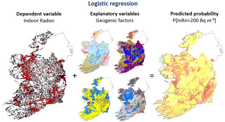
A new high spatial resolution radon risk map of Ireland has been developed, based on a combination of indoor radon measurements (n = 31,910) and relevant geological information (i.e. Bedrock Geology, Quaternary Geology, soil permeability and aquifer type). Logistic regression was used to predict the probability of having an indoor radon concentration above the national reference level of 200 Bq/m3 in Ireland. The four geological datasets evaluated were found to be statistically significant, and, based on combinations of these four variables, the predicted probabilities ranged from 0.57% to 75.5%. Results show that the Republic of Ireland may be divided in three main radon risk categories: High (HR), Medium (MR) and Low (LR). The probability of having an indoor radon concentration above 200 Bq/m3 in each area was found to be 19%, 8% and 3%; respectively.
In the Republic of Ireland, the population affected by radon concentrations above 200 Bq/m3 is estimated at ca. 460 k (about 10% of the total population). Of these, 57% (265 k), 35% (160 k) and 8% (35 k) are in High, Medium and Low Risk Areas, respectively. Our results provide a high spatial resolution utility which permit customised radon-awareness information to be targeted at specific geographic areas.
Javier Elío
Associate Professor
My research interests include environmental sciences and data analysis.